About Banque Populaire
Banque Populaire group is the fourth banking cluster in France. This cluster includes 12 Regional Banque Populaire and two national banks, Crédit Coopératif and CASDEN Banque Populaire.
Key player in the regional economy, Banque Populaire supports and encourages boldness of all entrepreneurs. As the largest bank for SMEs and craftpersons, Banque Populaire is the leader in business start-up loans.
Key figures
- Regional bank present in 7 departments;
- 140 bank agencies;
- organized into 9 groups;
- 360,000 customers;
- 20 years experience of geomarketing.
The challenge
Making geomarketing accessible to agency directors
For more than 20 years, Banque Populaire de l’Ouest (BPO) has been using geomarketing tools to conduct its location studies and optimize the sales sectoring of its 140 agencies. A couple of years ago, a new management team is installed and decides to look at the use of geomarketing and defines three objectives:
- involve each agency director by providing him/her with the local mapping reports describing his various sectors to assist targeted prospecting,
- lend new projects a geographical dimension,
- conduct location studies by analyzing high potential areas and customer behavior.
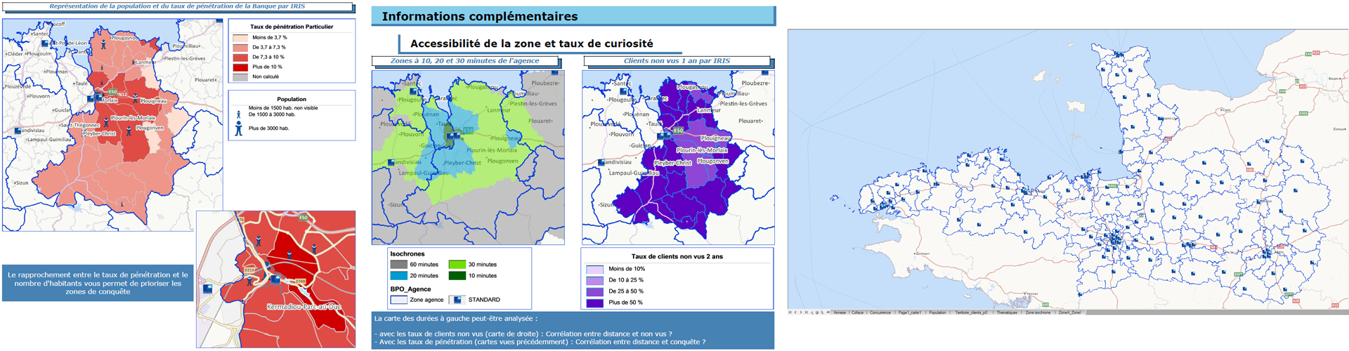
The BPO then initiates a market analysis to select a new service provider, tasked with proposing an optimal solution for creating simple and visual geomarketing reports. These reports, including sectoral analyses, were to be provided by the geomarketing department to the 140 agency directors to enable them to gain a better understanding of their territory and prioritize where in them to take action.
La solution apportée par GEOCONCEPT
Geoconcept Sales & Marketing was chosen for this project, notably for its performance and ease of use, which makes the tool very intuitive. Once the IT system data had been imported and customer geocoding performed the solution was quickly implemented. Today it enables BPO’s geomarketing department to generate sectoring for each agency, all of which have their own territory. This enables sales potential and performance studies to be carried out, in particular by comparing analyses of the different territories. Geoconcept Sales & Marketing also features a reporting module enabling the automatic generation of PDF reports. This module enables the 140 agencies to use the same report template, with the ability to work at different scales and combine text and graphs, tables or even maps for optimal legibility.
The BPO motto: simplicity!
Reading and accessing information is simplified by the reporting module, which features a clever system of “bands” for optimal formatting. It should be noted that the tool also provides customization options depending on the requests and problems being dealt with. Standardized reports enable each agency director to compare his results with those of the group, thereby gaining a very clear view of his performance and potential. He now has all the tools to hand for controlling his own sales development and prioritizing where to act.
Discover Geoconcept Sales & Marketing
"The outcome far exceeds our expectations. The GEOCONCEPT solution enabled us to considerably simplify our network’s geomarketing data by making them ultra legible and relevant for local decision-makers."

White paper: Commercial and logistical territory management
Definitions, methodology, analysis… This white paper aims to give you the keys to understand territory management principles and main interest for sales activities.
Autres cas susceptibles de vous intéresser